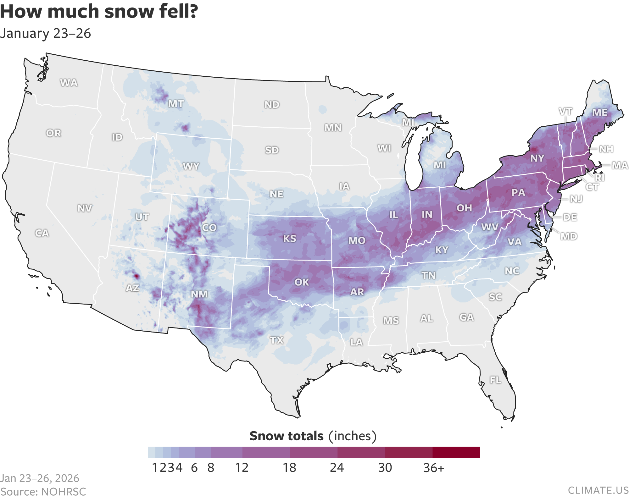
It’s that time of year. By that I mean it’s time for our annual reminder that, yes, the U.S. can have big winter storms, record snowfall, and extreme cold even with global warming. At least once a season, a storm big enough and severe enough to dominate the national news gets people wondering about how to make extreme winter events make sense in the context of global warming. This year’s trigger was a sprawling system that slathered large parts of the eastern United States with snow, sleet, and ice between January 23-26.
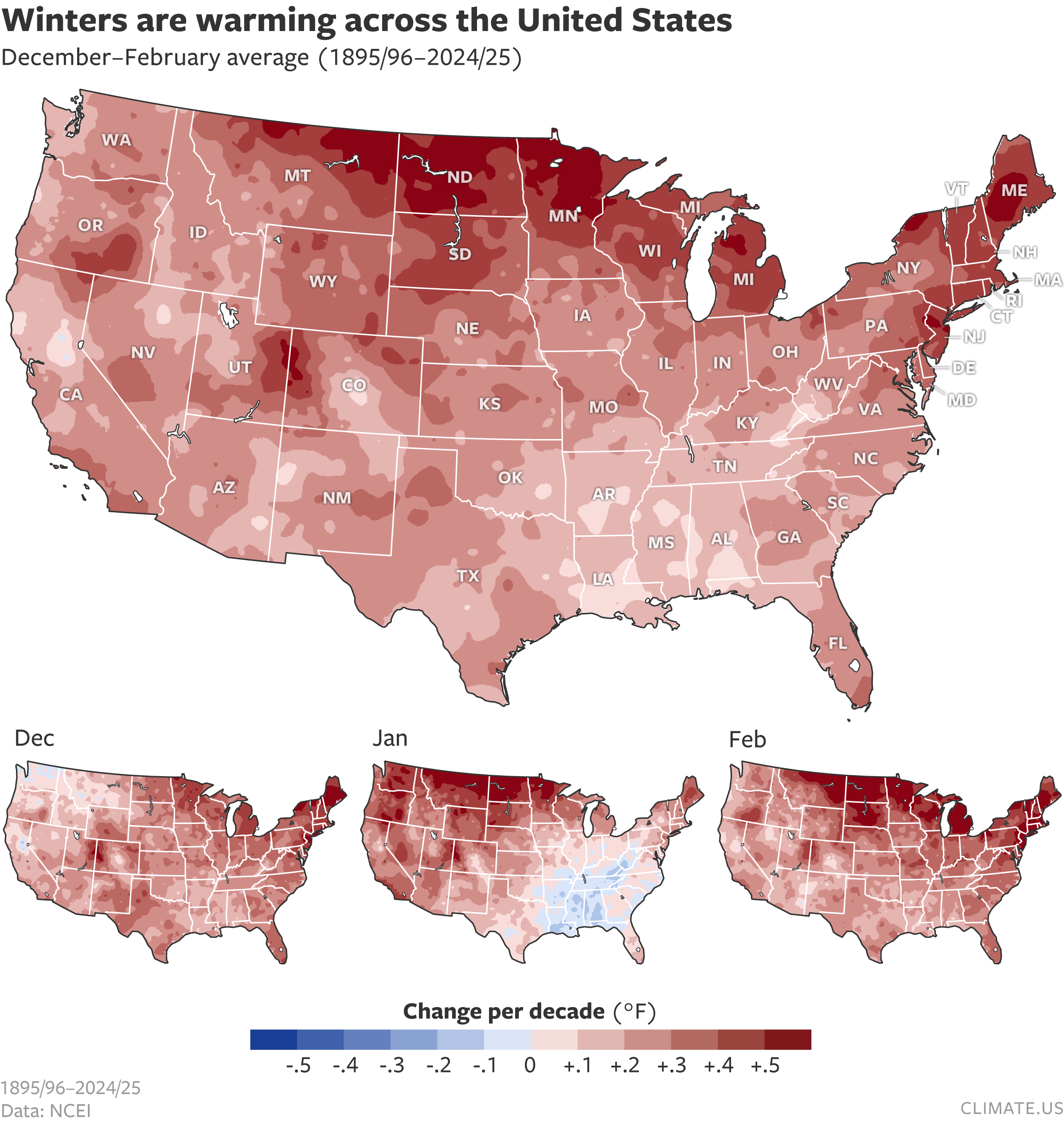
The short answer is that events like the January 23rd storm capture headlines and attention, but they don’t occur often enough to outweigh the long-term influence of human-caused global warming on U.S. winter temperatures. For the United States as a whole, winter is the fastest-warming season.
If you don’t have time to read any further, that’s the big-picture take away. Winter is getting warmer, but not so warm that snow and ice storms aren’t still possible. “The most fundamental thing we can say about cold extremes,” says polar climate scientist Jacob Chalif, a researcher at Dartmouth College, “is that we know they are getting warmer, getting less frequent because of long-term climate change.”
But what about the U.S. “warming hole”?
Despite the memes and misinformation they trigger, big snowstorms don’t actually need any special explanation to make them make sense in the context of climate change. There are plenty of places in the United States where temperatures will have to warm a lot more before it would stop snowing altogether. We wrote about this on Climate.gov in 2010, 2015, and 2017. Still, there is something curious about the maps of U.S. temperature trends: less warming in the South-Southeast. Climate scientists call this feature the “U.S. warming hole”.
For much of the past two decades, experts have been trying to explain what caused the region to lag the global-scale warming trend for part of the 20th century. One of the first things they teased out was that what’s causing the pattern in summer is likely different from what’s causing it in the winter. In winter, many studies have focused on the possibility that rapid warming of the Arctic has caused the mid-latitude jet stream to become wavier, with deeper troughs and taller ridges.
Since jet stream troughs allow cold air from Canada to reach deeply into the South, the hypothesis goes, maybe an increase in jet stream waviness has been allowing cold air and winter storms to reach into the southern U.S more deeply or frequently than they have done historically. If that were true, it would mean global warming could be causing—paradoxically—more cold extremes across the United States.
Despite more than a decade of research, evidence for this hypothesis remains inconclusive. At the same time, more nuanced versions of it have emerged, with scientists proposing that a different mix of factors is at play in different seasons and different parts of the midlatitudes. Scientists continue to disagree about virtually all aspects of the hypothesis: whether cold extremes have become more common or intense in some locations or whether they haven’t; whether the jet stream’s waviness in recent decades is historically unusual or whether it’s not; whether the stratospheric polar vortex could be playing a significant role in cold extremes in recent decades, and if so, whether its recent behavior is unusual or not.
As a case in point, Chalif and his colleague Erich Osterberg recently published results from a study in which they used observations and weather models to reconstruct the behavior of the jet stream back to the start of the 20th century. According to this analysis, the waviness of the jet stream since the 1990s—when Arctic warming really began accelerating relative to global average warming—isn’t particularly dramatic. In fact, waviness was more extreme for periods of the mid-1900s than it has been recently.
“The heightened waviness of the 1960s to 1980s lines up well with the period of the strongest part of the U.S. winter warming hole,” says Chalif. You can see the patterns in this graphic from the paper. He and his colleague estimated that the jet stream waviness of those decades can account for about 2/3 of the U.S. winter warming hole. The rest may be linked to changes in the levels of air pollution, which affects cloudiness; the re-growth of forests; or the expansion of agricultural irrigation.
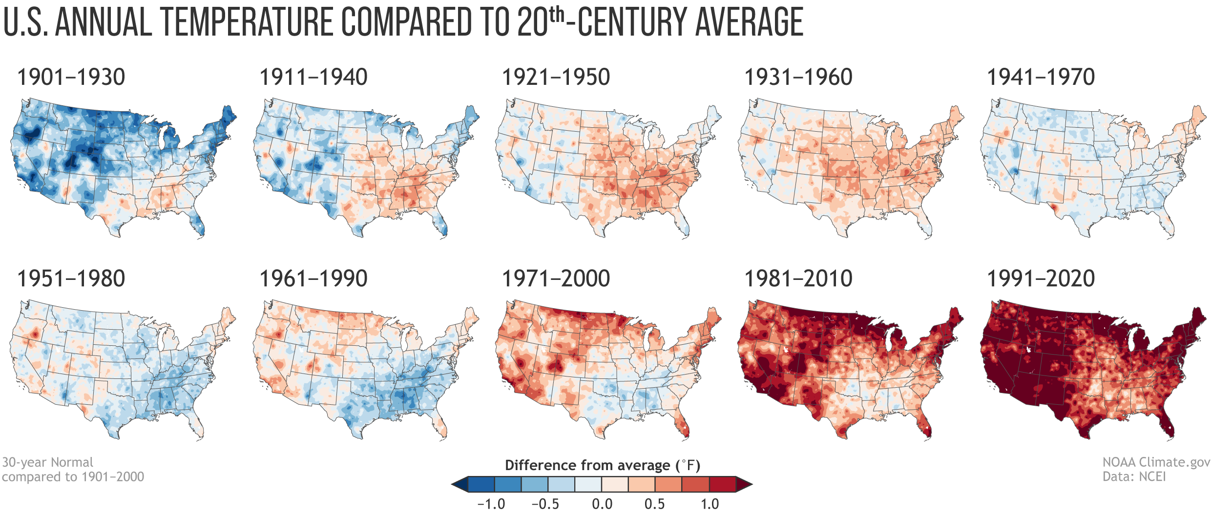
The stronger waviness in those decades compared to recent decades is also consistent with the fact that “the winter warming hole is disappearing,” says Chalif. You can see this happening in maps of annual U.S. temperatures for each of the official U.S. Climate Normals periods since the record began at the start of the 20th century.
To Chalif, the U.S. winter warming hole looks less like a direct response to global warming or Arctic amplification, and more like the result of a rare alignment of natural variability in the jet stream with other human influences. The alignment allowed the Southeast to march out of step with the global warming trend for a while, but that era appears to be ending. Since 1991, winters in the Southeast have been warming at a rate of 0.6 F per decade—twice as fast as the national average.
“Our work points to the conclusion that climate change isn’t affecting the jet stream more than natural variability would lead us to expect,” Chalif wrote in a follow-up email, “at least not yet.”
But even if the original version of the hypothesis connecting global warming to winter weather is ultimately rejected by the scientific community at some point in the future, Chalif continued, it will still have been valuable. “That hypothesis launched a whole subfield of climate research,” he pointed out, “leading to novel and exciting ways of thinking about how what’s going on in the Arctic affects us in the mid-latitudes.”
The winter weather-water vapor connection
In an online panel discussion that took place earlier this week, Chalif’s co-author Erich Osterberg emphasized that while the potential connections between winter weather, cold extremes, and Arctic warming are unsettled, there is a lot more confidence that global warming is influencing storms, including winter storms, through increases in atmospheric water vapor.
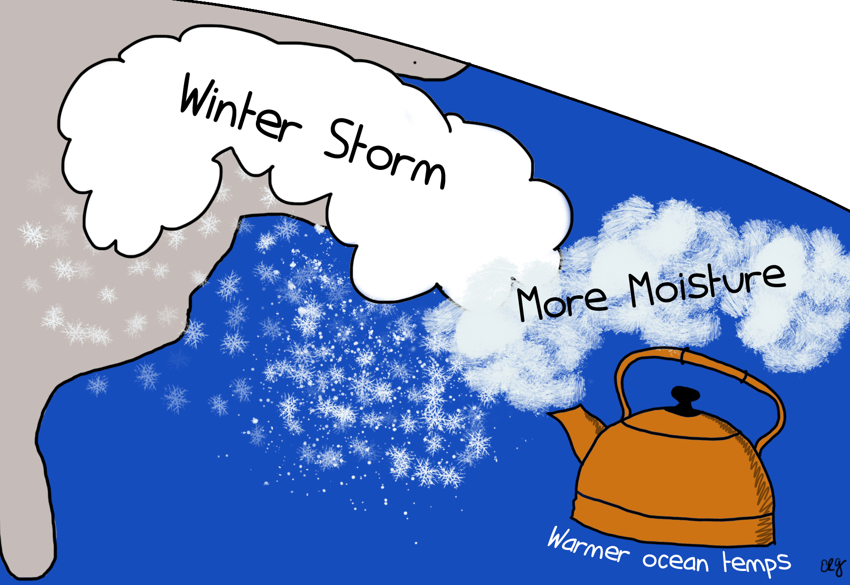
The amount of water vapor in the atmosphere is increasing due to increasing evaporation from warming oceans. More water vapor in the atmosphere is increasing rain rates and total precipitation during many kinds of storms, including winter storms. Osterberg noted that prior to the January 23rd storm, water temperatures in the Gulf of Mexico were extremely warm. That extreme contrast with the cold air coming down from the North may have added to the storm’s intensity.
More information
Further reading on Arctic warming, the polar vortex, and midlatitude weather
- Factcheck: Global warming is not making extreme cold more common
- Understanding the Arctic polar vortex
- Clarity and clouds: Progress in Understanding Arctic Influences on Mid-latitude Weather
- Blocking and its response to climate change
Data
- Modeled Snow Water Equivalent, NOHRSC.
- National Temperature Trends, NOAA NCEI.
- U.S. Climate Normals 1991-2020, NOAA NCEI.