A new study from researchers at UCLA and the University of Houston reveals estimates of significant groundwater loss in California’s Central Valley during the recent drought and sparks questions of …
News & Features
A new study from researchers at UCLA and the University of Houston reveals estimates of significant groundwater loss in California’s Central Valley during the recent drought and sparks questions of …
A new study from researchers at UCLA and the University of Houston reveals estimates of significant groundwater loss in California’s Central Valley during the recent drought and sparks questions of …

A new study finds that most phytoplankton productivity occurs before sea ice breaks up. The finding suggests that nutrients like iron are supplied by melting ice, feeding phytoplankton communities.
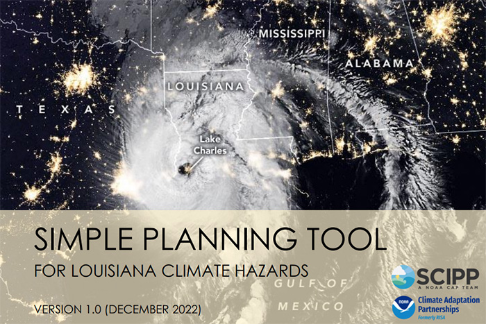
The Simple Planning Tool for Louisiana Climate Hazards is a compilation of relatively easy-to-use online interactive tools, maps, and graphs relevant to 17 hazards: 14 climate hazards and 3 non-climate hazards. The tool is also available for Oklahoma, Arkansas, and Texas.
A new modeling study led by NOAA researchers highlights the challenges and potential consequences of solar geoengineering actions large enough to ward off extreme warming by the end of the 21st century. The study simulates the injection of sulfur dioxide into the atmosphere to counter carbon dioxide emissions. The study finds that sulfur dioxide injections of up to 50 million metric tons per year would be needed to keep temperatures from rising.
Key Findings A 50km high-resolution version of the AM4 atmospheric model captures many aspects of the observed atmospheric river (AR) characteristics well. Despite significant regional biases, the…
One fun fact is that the Air Resources Laboratory has maintained a network of accurate United States climate data for over 20 years.
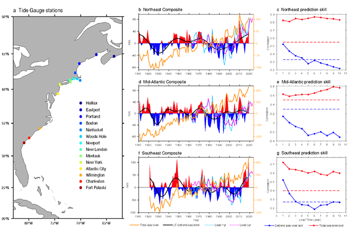
A new study finds that sea level variations along the U.S. East Coast are skillfully predictable 3 to 10 years in advance over the North Atlantic regions. The most predictable sea level component is characterized by a basin-wide upward trend.
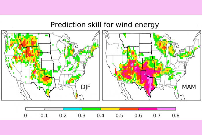
NOAA’s Seamless System for Prediction and EArth System Research (SPEAR) shows great skill at predicting year-to-year variability in wind energy, especially in spring over the Southern Great Plains, where more than half of the total U.S. wind capacity is located.